The Netherlands 2024 review
Read our weather, climate and electrical analysis of thunderstorms in the Netherlands in 2024.
2024 at a glance
With more than 17,800 cloud-to-ground lightning flashes (lightning strikes) detected, 2024 was within the normal climatic range for the Netherlands. Most of the electrical activity was concentrated in the period from May to September, with the exception of June, which was marked by atmospheric stability.
Classic summer downturns
July, August and September saw a number of significant thunderstorms. These typical downgrades were fuelled by wet, unstable flows associated with disturbed systems (cold drops) passing through western Europe.
Autumn cold air mass thunderstorms
The remainder of the electrical activity, which is more limited, is attributed to thunderstorms linked to cold air masses. These phenomena, common in autumn, result from incursions of cold air from the North Sea. The thermal contrast with the waters, which are still relatively mild in relation to the land, encourages the formation of thunderstorms, which are characteristic of a ‘trailing sky’, accompanied by precipitation and lightning.
Joris Royet, Weather Project Manager, METEORAGE.

Our METEORAGE network – the European Lightning Detection Network (ELDN) detected in the Netherlands, in 2024
Key facts
The day most struck by lightning
August 13, 2024
The month most struck by lightning
May 2024
The County most struck by lightning
Boger-Odoorn
Focus on
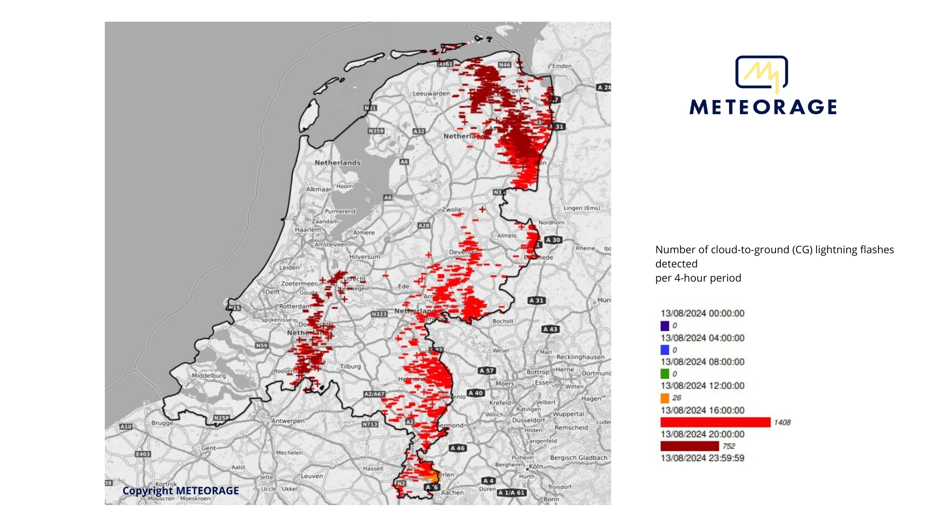
Violent thunderstorm on 13 August
by Joris Royet, Weather Project Manager, METEORAGE.
A trough over western Europe
In mid-August, despite an atmospheric belt positioned towards the mid-latitudes, a trough managed to plunge towards Brittany, generating a powerful thunderstorm system ahead of it, in a dynamic southerly flow. These thunderstorms, initially present over France, progressed towards Belgium before intensifying as they reached the east of the Netherlands.
Conditions conducive to severe thunderstorms
In the Netherlands, the first thunderstorm cells hit the south-east of the country at around 5.00 pm, developing into a vast MCS-type thunderstorm system which crossed the country from south to north throughout the evening. The cold, widespread cloud tops, characteristic of severe thunderstorms, reflect strong updrafts. In addition, the CAPE (Convective Available Potential Energy) frequently exceeds 2300 J/kg, providing a large reservoir of energy for the intensification of thunderstorms.
Intense electrical activity
This thunderstorm episode was accompanied by intense electrical activity, with more than 2,100 cloud-to-ground lightning flashes recorded by the METEORAGE network (ELDN), as well as intense phenomena such as violent gusts and sustained rainfall.
CG lightning flash map
August 13th, 2024

On August, 11th
2,186 Cloud-to-ground (CG) lightning flashes detected, including:
+ Positiv CG lightning flashes: 133,
– Negativ CG lightning flashes: 2,053.
Lightning strikes in the Netherlands in 2024
For 2024, the lightning density for the Netherlands is 0.4688 cloud-to-ground lightning flashes per km².
Seasonality of thunderstorms
Seasonal distribution of CG cloud-to-ground lightning strikes.
Move over the graph to view the data.
The frequency, geographical distribution and intensity of thunderstorms vary with the seasons, depending on temperature, humidity and atmospheric dynamics.
In spring, thermal contrasts between cold and warm air set in and encourage the first convective thunderstorms, often accompanied by intense rain and sometimes hail or tornadoes, with electrical activity increasing as the season progresses.
In summer, they are more frequent and violent, fuelled by high temperatures and strong contrasts when cold drops pass through, generating thunderstorms that are sometimes supercellular, hence a peak in activity during this season.
Autumn sees a gradual reduction in electrical activity, but lows can still produce thunderstorms linked to transitions between air masses, particularly near waters that are still relatively warm.
In winter, although less frequent, thunderstorms can occur, often near the oceans or in regions where cold fronts meet warmer, more humid air.
Top 10 Provinces most struck by lightning
by number of cloud-to-ground (CG) lightning flashes
Move over the graph to view the data.
by lightning density of cloud-to-ground (CG) lightning flashes per km²/year
| 01. Groningen | 0.624 |
| 02. Gerderland | 0.621 |
| 03. Limburg | 0.617 |
| 04. Drenthe | 0.616 |
| 05. Overijssel | 0.572 |
| 06. Noord-Brabant | 0.544 |
| 07. Zeeland | 0.348 |
| 08. Noord-Holland | 0.340 |
| 09. Utrecht | 0.336 |
| 10. Flevoland | 0.311 |
Top 10 Municipalities most struck by lightning
by number of cloud-to-ground (CG) lightning flashes
Move over the graph to view the data.
by lightning density of cloud-to-ground (CG) lightning flashes per km²/year
| 01. Hellendoorn | 1.70 |
| 02. Hattem | 1.65 |
| 03. Achtkarspelen | 1.50 |
| 04. Borger-Odoorn | 1.45 |
| 05. Brunssum | 1.44 |
| 06. Meerlo-Wanssum | 1.41 |
| 07. De Marne | 1.37 |
| 08. Kollumerland | 1.32 |
| 09. Reusel-De-Mierden | 1.28 |
| 10. Heerlen | 1.22 |
The lightning strike on the Netherlands in recent years
Since 2007, the lightning density for the Netherlands has been 0.2359 cloud-to-ground lightning flashes/km² per year.
The average number of thunder days is 51 per year.
Over the last 3 years
Monthly distribution of lightning strikes
Number of cloud-to-ground (CG) lightning flashes detected each month
Move over the graph to view the data.
Over the last 10 years
Annual distribution of lightning strikes
Number of cloud-to-ground (CG) lightning flashes detected each year
Move over the graph to view the data.
Annual distribution of thunder days
Number of thunder days detected annually
Move over the graph to view the data.
Terminology
To help you better understand the information in this report, here are the definitions for some of the most frequently used terms.
Cloud-to-ground (CG) lightning flash
Discharge of current of a certain intensity circulating between the cloud and the ground. Abbreviated to CG (Cloud-to-Ground).
Lightning density
The best current representation of thunderstorm activity is lightning density, which is the number of cloud-to-ground (CG) lightning flashes per km² per year.
Lightning flash
All current discharges and electrical impulses from a lightning event. A lightning flash can occur within the same cloud (IC), between a cloud and the ground (CG) or between two clouds (CC). A lightning flash can be composed of one stroke or many strokes, which are current discharges and electrical impulses.
Thunder day
Each day that lightning was detected in a given area.
About this lightning report
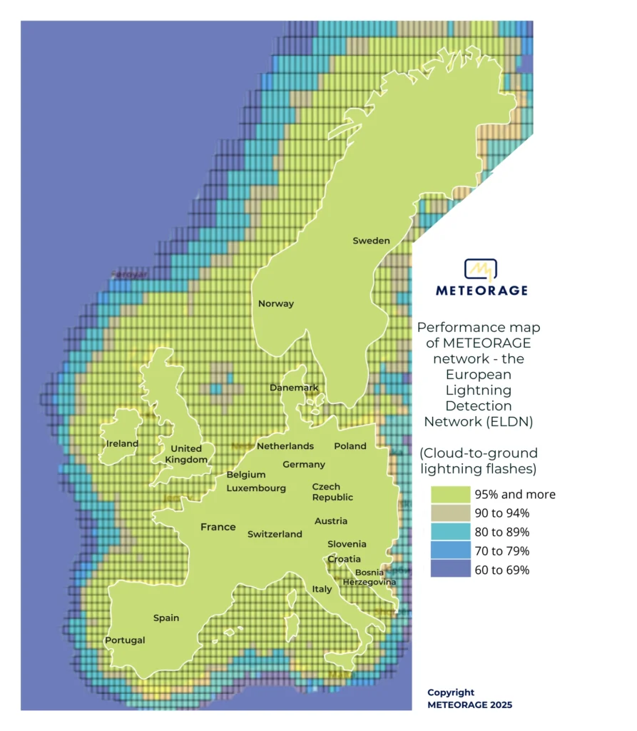
The lightning report is based on data provided by the METEORAGE network – the European Lightning Detection Network (ELDN).
The information we provide concerns cloud-to-ground (CG) lightning flashes and lightning density.
To be able to compare these data with the data collected, METEORAGE counts the main current pulse circulating between the cloud and the ground, defined in this report by the term “Cloud-to-ground (CG) lightning flash”.
Our expertise draws on more than ten years of analysis, observation and data collected in Europe, and more broadly worldwide. We have over 37 years’ expertise in France.
The performance of our network has been validated scientifically and delivers the best possible results with:
- > 98% lightning flash detection,
- a median detection accuracy of 100 meters,
- > 90% distinction made between cloud-to-ground (CG) lightning flashes and intra-cloud lightning flashes.
The METEORAGE network (ELDN) consists of more than 100 lightning sensors, calculators and a processing system that manages the databases. Our lightning sensors are based on the Vaisala technology, currently considered one of the best in the world. Our network achieves levels of performance validated by numerous scientific studies and publications.
This 2024 report is based on the most comprehensive source of information in the Netherlands. The data, densities, rankings and thunder days in this report are dated from 1 January 2024 to 31 December 2024.

